![]()
Note: This is the original outing plan, which has not been updated to match changes in the actual trip.
Entiat Outing:
Emerald, Saska, Cardinal, Pinnacle, & Pyramid
October 8-12, 2004
USGS Quadrangle(s): Mt. Pyramid Mountain, Saska Peak,
Pinnacle Mountain
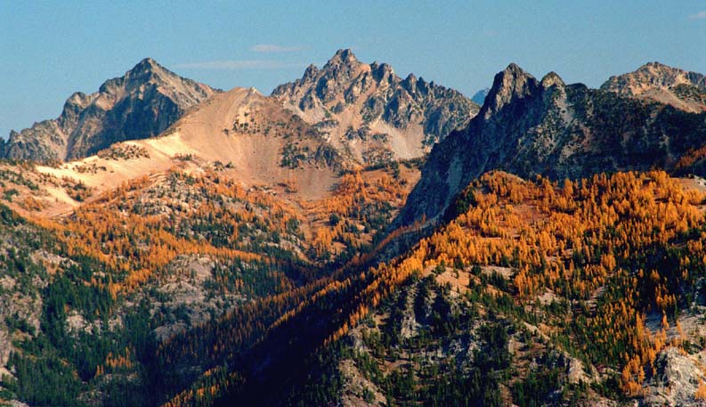
Saska, Gopher, Emerald, Choral, & Cardinal (viewed from Rampart Mountain, 10/8/00)
Contents
Itinerary
Day 0: Optional
drive to North Fork Entiat TH. 190
miles, 4.5 hours.
Day 1: Hike from TH to Emerald basin camp via trails 1437 and 1433. 9.2 miles, 3000 gain.
Day 2: Scramble
Pinnacle. 11 miles, 5200 gain, round
trip.
Day 3: Scramble
Cardinal. 3 miles, 2100 gain, round
trip.
Scramble
Emerald. 1.5 miles, 1400 gain, round
trip.
Day 4: Scramble
Saska. 2 miles, 1700 gain, round
trip.
Move camp
to Three Tree Camp (junction of trails 1433 & 1438). 4.6 miles, 1150 gain, 1550 loss.
Optional
scramble of Skidgravel. 2 miles,
1400 gain, round trip.
Day 5: Scramble
Pyramid. 1.5 miles, 1700 gain, one
way.
Optional
return to camp via Sqaretop. 2.5
miles, 450 gain, 2100 loss, from Pyramid to summit to camp.
Hike trails
1438 and 1437 to TH. 7.3 miles, 600
gain, 3200 loss.
The priority will be to complete scrambles of Pinnacle, Cardinal, Emerald, and Saska.
If we encounter delays due to weather or other problems, then the first four days will be used to complete as many of these as possible, and the exit will be made on the fifth day via the entry route, rather than the longer two-day exit described above.
Driving Instructions
Drive to Wenatchee (via US 2 or via I-90 and US 97). Continue 19 miles north on US 97 to the town of Entiat. Turn left on Entiat River Road FS 51. The North Fork Entiat Road FS 5606, forks right just after Entiat Falls, and before the North Fork CG. The North Fork Entiat River TH is at the end of the road, about 2 miles. 190 miles, 4.5 hours.
Approach Trail & Camps
North Fork Entiat TH to Emerald basin high camp:
From the 3900 ft TH, follow North Fork Entiat River trail 1437 north for 8 miles to its junction with Pyramid Mountain Trail 1433. Continue north 1.2 miles to high camps in the 6900 ft basin between Emerald & Saska. 9.2 miles, 2900 gain.
It may also be possible to camp half a mile further south in the basin below Cardinal Peak at about 6600 feet.
This would shorten the approach and the Cardinal scramble, but it would lengthen the Pinnacle, Emerald, and Saska scrambles.
Exit Trails & Camp
Exit Part A:
Emerald Basin Camp to Three Tree Camp (junction of trails 133 &
1438):
From Emerald Basin, take trail 1433 south and east over
Grouse Pass to its junction with trail Pugh Ridge Trail 1438. 4.6 miles, 1150 gain, 1550 loss.
There is a possible camp at this junction called Three Tree Camp.
Scrambles en route:
Scramble to Pyramid from Three Tree junction.
Additional possible bonus scrambles are Skidgravel, departing the trail north of Grouse Pass, and Squaretop, which can be reached from Pyramid or from Grouse Pass.
Exit Part B, Three Tree Camp to North Fork Entiat
Trailhead:
Take 1438 south to junction with trail 1437. Take 1437 south to TH. 7.3 miles, 600 gain, 3200 loss.
Total trail mileage for exit: 11.9 miles, 1750 gain, 4750 loss.
Pinnacle Mountain 8402
The true summit is the southern of the two highest summits at the NW end of the mountain.
From Emerald Basin Camp, take Trail 1433 W over Saska Pass and down to Emerald Park Trail 1230 at 5800 feet. Hike NE toward Milham Pass for 0.6 miles to the junction with 45-Mile Sheep Drive Trail 1432, where the trail becomes hard to find. Angle up the western slope to a pass between two rocky buttresses and a saddle W of the 6767 knob. The trail reappears from time to time. After passing the knob, continue N into the meadows, beginning at about 6800 feet. At the second meadow at 7100 feet, turn W and ascend a heather and grassy slope with a short bit of talus. The trail reappears above the talus and makes an easy path to Borealis Pass at 7660 feet.
From the pass, contour N just below the crest of the ridge to reach the saddle S of Pinnacle. From the saddle, ascend the steep gravelly slope to the summit ridge. On the ridge, turn right to the summit, with class 2 scrambling and little exposure.
For return, descend to the 7100-foot meadow through steep, loose talus and scree, and follow remainder of route back to camp.
Difficulty R-3. 5.5 miles, 3300 gain, 1900 loss, one way. 11 miles, 5200 gain, round trip.
Cardinal Peak 8595
From Emerald Basin Camp, take trail 1433 south to get opposite the middle summit of Cardinal, circa 6700. Then ascend through open forest to the wide talus slope and continue up the gully to the ridge notch between the middle and north summits. Follow the ridge south to the middle summit.
Difficulty R-4. 1.5
miles, 260 loss, 1880 gain, one way. 3
miles, 2140 gain, round trip.
Emerald Peak 8422
From Emerald Basin Camp, scramble north to the upper basin just below the ridge between Emerald and Saska. Stay high enough to see the broad gully leading to the summit. There appear to be three summits. Climb to the notch between the left and middle summit. Turn right and climb a short rock step to the upper talus field. Walk easily to the middle summit.
Difficulty R-3.
Beware of the gully that is full of loose rock. .75 miles, 1400 gain, one way. 1.5 miles, 1400 gain, round trip.
Saska Peak 8404
From Emerald Basin Camp, take trail 1433 west 0.5 mile to 300 feet short of the first switchback to Saska Pass. Leave the trail and scramble up the hill into the basin south of Saska. A broad gully leads steeply up and left to the ridge. Climb to the notch to the right of an area of red rock. Go over the ridge and drop slightly, traversing north about 300 feet. A series of benches and a steep gully leads up to the south ridge. Beware of serious rock fall danger and loose handholds. Scramble on the south ridge on the left to the airy summit. Several gullies on the south and southeast are also feasible.
Difficulty R-4.
Serious rock fall danger. 1
mile, 120 loss, 1580 gain, one way. 2
miles, 1700 gain, round trip
Pyramid Mountain 8245
From Three Tree Camp (junction of trails 1433 & 1438), follow the ridge east toward the summit of Pyramid. At about 7700, find the Pyramid Mountain Trail and follow it the remainder of the way to the summit. 1.5 miles, 1700 gain, one way. 3 miles, 1700 gain, round trip.
Bonus Peaks: Skidgravel Point 8339, Squaretop Mountain 8189
These are optional side trips that may be added if time and party interest allows.
Skidgravel Point:
From the Pyramid Mountain Trail 1433, depart the trail about
0.3 miles N of Grouse Pass, when the trail makes a sharp turn south at about
6950 feet. Ascend north through meadows
to Skidgravel Gap, 7205. Struggle in
the loose scree NW to the summit. 1
mile, 1400 gain, one way. 2 miles, 1400
gain, round trip.
Squaretop Mountain:
From Pyramid Mountain, traverse the ridge north to the summit of Squaretop. 0.9 mile, 530 loss, 440 gain.
To return, descend the upper W and SW slopes to the head of
the east terminal fork of South Pyramid Creek.
Then descend west to Trail 1433 just south of Grouse Pass 7262, and
follow the trail south to Three Tree Camp 6527. 0.9 miles, 1670 loss, one way.
Total mileage Pyramid to Three Tree Camp: 1.8 miles, 2200 loss, 440 gain.
Map
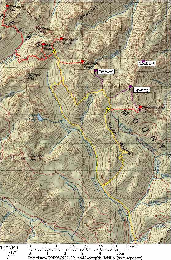
Trail routes with full packs are marked in yellow.
Scrambles to summits are in red.
Optional bonus scrambles are in purple.
Leader
Matt Burton
(425) 774-6491 (home)
(206) 713-3426 (cell)
Email Matt Burton